Research & Article
François Valentijn’s Map of “The Great Siamese River Me-Nam”
By Barend J. Terwiel
Published on 9 May 2024
History
Location of original sources
Journal of the Siam Society (JSS) Vol. 105 (2017)
Download
François Valentijn’s Map of “The Great Siamese River Me-Nam”
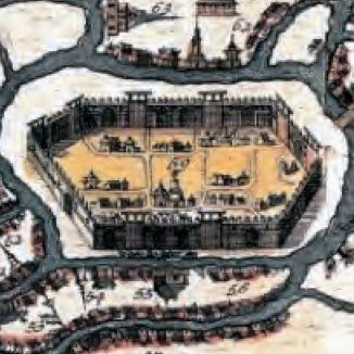
Between 1724 and 1726, François Valentijn (1666-1727) published Oud en Nieuw Oost-Indiën, a monumental work on the Dutch East India Company (“VOC”). In Volume 3, Part 2, Book 6, Chapter 1 (the section dealing with Siam), between pages 60 and 61, Valentijn placed a large map (74 cm long, and 29.4 cm high) depicting a large part of Siam.2 Prominently in the middle of this map he drew a large scroll with the words: “De Groote Siamse Rievier Me-Nam ofte Moeder der Wateren in haren loop met de in vallende Spruyten Verbeeld,” which may be translated as: “The Great Siamese River Me-Nam, or Mother of Waters, its course and its tributaries displayed.” Hereafter this map will be referred to as “VAL”. Valentijn mentions that the map contains unique information, and it will be shown below that this is indeed the case.